History

March 18, 2016

The Notorious RBG: Exploring Ruth Bader Ginsburg’s Brooklyn Roots

Though news this week has been focused on President Obama choosing Merrick Garland as the next Supreme Court justice, it's Ruth Bader Ginsburg who's been grabbing headlines for most of the recent past. And as Brownstoner recently pointed out, "the Notorious RBG, as Supreme Court Justice Ruth Bader Ginsburg is known to her fans, shares a home borough with the original Notorious title holder — the late rapper Biggie Smalls, aka the Notorious B.I.G."
Learn all about RBG's Brooklyn roots
March 16, 2016

Go Inside the Trippy Apartments of 1970s Urban Dwellers

Mid-century modern is often touted as the ideal when it comes to design, but while that era gifted us beautiful and timeless works from the likes of Mies and Charles and Ray Eames, not everyone at the time was keen on keeping with this design aesthetic. As the 70s gave way to a slew of political and social change, many homes also saw revolution of their own from the streamlined to the downright psychedelic. Case in point: All of the interiors featured in old issues of Apartment Life, a city living lifestyle magazine from the 70s. But what might be better than ogling all the decades-old acid trip decor in these old issues is reading the captions of the glossies. Like the folks featured in our My sqft series, Apartment Life talks the challenges of urban living (like no-view windows and limited storage), in addition to offering up some tips on how to deal (solution: build yourself a "butcher block storage/coffee table" they say!). They've even got a great idea for beating the below-zero blues: A "Winter Picnic" in bed.
Go inside these apartments here
March 15, 2016

This Illustrated 1926 Map of Manhattan Shows the City as It Was, Both Fanciful and Familiar

This fascinating vintage map of "The Wondrous Isle of Manhattan” is an illustrated version of the island as it existed in 1926, when it was designed and illustrated by Charles Vernon (C.V.) Farrow (1896-1936) and published by Fuessle and Colman. The map, though not to scale, highlights scores of actual attractions like landmarks and parks. Familiar buildings and streets are labeled, as is the city’s transit system at the time, with elevated tracks running along the avenues.
Look closer for details of 1926 life in wondrous Manhattan
March 14, 2016

One-Cent Coffee Stand Fed Hungry New Yorkers Back in the Day

The corner coffee cart is a well-known part of New York City's landscape, but it may have been first actualized as a much more charitable endeavor. Back in 1887, the first one-cent coffee stand for poor New Yorkers opened on Ann Street off Broadway. Standing in front of City Hall's high-octane newspaper offices of Park Row, St. Andrews One Cent Coffee Stand served a half-pint of coffee with milk sugar and a slice of bread for just a penny.
READ MORE
March 13, 2016

Downtown Wonder: How One Chase Manhattan Plaza Changed the New York Skyline

This large, boxy skyscraper at 28 Liberty Street may not be ornate or even as attractive as some of the simple glass towers we see sprouting up on the city’s side streets, but One Chase Manhattan Plaza’s architectural significance is profound. Erected in 1960, the building is accredited with bringing forth a downtown renaissance that paved the […]
March 8, 2016

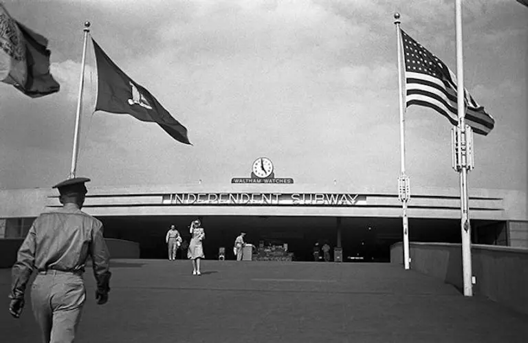
The Lost Subway Line of the 1939-1940 World’s Fair

There was, for a short time, a line of the IND (Independent) subway that was built for the 1939/1940 World’s Fair in Flushing Meadows-Corona Park, the second most expansive American world's fair of all time (second only to the St. Louis Louisiana Purchase Exposition of 1904). The event brought over 44 million people to the Flushing Meadows-Corona Park site. To make visting the fair more convenient, the city created a new dedicated subway line extension and terminal, then the only line owned by the city. The extension began on a bridge (called a flying junction) running through Jamaica Yard near what is now the Forest Hills-71st Street stop on today's M/R lines. The extension turned north along the east side of Flushing Meadows-Corona Park over a wooden trestle and ended at the newly-created World’s Fair Terminal Station, which had two tracks and three platforms. The two-mile addition cost $1.7 million to build.
Find out what happened
March 3, 2016

The Bedrock Myth: The Evolution of the NYC Skyline Was More About Dollars Than Rocks

The reason so many skyscrapers are clustered Downtown and in Midtown isn't so much because of geological feasibility as because everybody else was doing it. It was long assumed that the depth of our venerable Manhattan Schist bedrock, well-suited for the construction of tall buildings, was the determinant in where the city's towers rose. Though the bedrock outcroppings are indeed at their deepest and closest to the surface in the areas where many of the city's tallest buildings are clustered, it's more likely to be coincidence than cause and effect. The real reason there's a big doughnut hole in the spiky man-made terrain between FiDi and Midtown has more to do with the way the city's dual business districts developed from a sociological and economic perspective between 1890 and 1915.
Find out why the bedrock myth is on shaky ground
March 2, 2016

The Urban Lens: Documenting New York City’s Vanishing Privilege Signs

6sqft's new series The Urban Lens invites photographers to share work exploring a theme or a place within New York City. In the first installment, award-winning authors and photographers James and Karla Murray brought us 15 years of images documenting the changing storefronts of Bleecker Street in Greenwich Village. Now they share more amazing images, this time of privilege signs, an industry term for the promotional signs installed by large corporations on storefronts. Are you a photographer who'd like to see your work featured on 6sqft? Get in touch with us at [email protected]. Privilege Signs are an industry term for the promotional signs installed by large corporations such as Coca-Cola and the Optimo Cigar Company. They were popular in the 1930s through 1960s and received their name because store owners were given the "privilege" of completing the signs with their own copy. Large companies benefited from the signs because they were an easy way of weaving a marketing campaign right into a building’s façade. The signs were not only given free to store owners, but they also brought people into the store with instant brand recognition. Today, they read retro and antique, standing out as a testament to a business' ability to endure even in the face of the monumental challenges in a city known for its rapid pace of change. When compiling our books on disappearing storefronts, we were immediately drawn to facades that still had these type of signs, so we've rounded up some of our favorites ahead.
See all the photos ahead
February 26, 2016

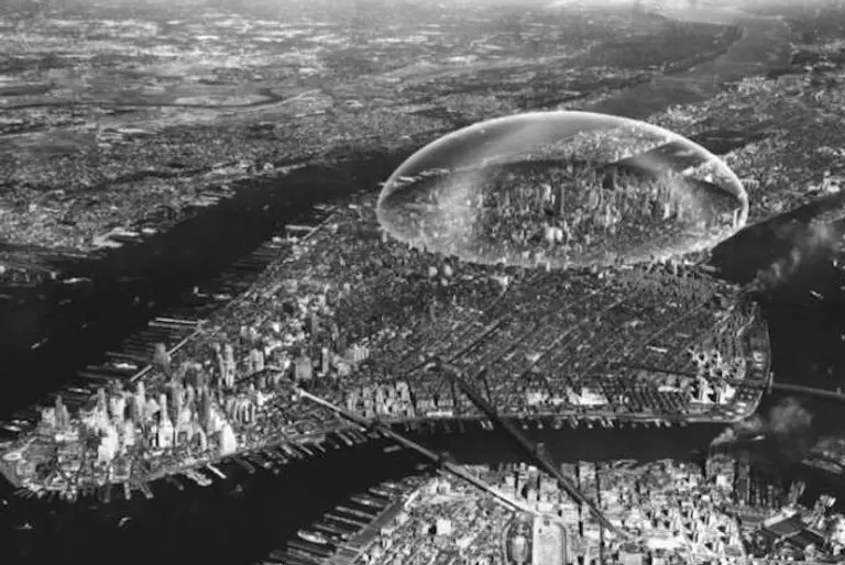
A 1960s Plan to Cover Midtown Manhattan With a Giant Geodesic Dome

During the 1960s and 1970s, thanks to future-thinking genius engineer/utopian Buckminster Fuller, plans were proposed to cover midtown Manhattan with a giant geodesic dome. Fuller, who invented the concept and was deeply invested in studying the domes and their properties, described a three kilometer (1.864 mile) geodesic dome spanning midtown Manhattan that would regulate weather and reduce air pollution. The proposed structure would have stretched from the East River to the Hudson River and from 21st Street to 64th Street. The dome would reduce cooling costs in summer and heating costs in the winter, so buildings wouldn't need separate heating or cooling–the dome above would be kept at a regulated temperature level.
Find out more
February 24, 2016

VIDEO: Fly Over the Forgotten Vessels of Staten Island’s Arthur Kill Ship Graveyard

In the Arthur Kill waterway, wedged between Staten Island and New Jersey, the Arthur Kill Ship Graveyard is the final home of over two dozen harbor vessels that had their best years in the city's golden age of shipping. There were once as many as 400 of the ghostly crafts left to the wiles of entropy in the waterway, but according to Atlas Obscura, only 25 or so remain, picked over for their useful parts. Seven minutes of eerie and fascinating drone video footage offers a close-up view of the "urban marine cemetery" and the rusted metal hulls of once-useful tugboats and other harbor ships as they slowly sink into the silent, murky waters.
More about this eerie assembly and the full video
February 24, 2016

How Far From NYC You Could Travel in One Day Between 1800 and 1934

Back in 1800, a New York stagecoach couldn't get outside the northeast, and a trip to Charleston, South Carolina took ten whole days of sailing—these are just two examples of just how arduous traveling in the 19th and early 20th centuries was. To visualize this difficulty, as well as to show the major advances made over a relatively short time, Quartz created this simple map that shows how far from NYC one could travel in a day between 1800 and 1934.
More on the map
February 22, 2016

Lions and Tigers and Buildings, Oh My! The Architecture of the Bronx Zoo

As home to four thousand animals representing more than 650 species, the Bronx Zoo has been delighting children and grownups alike since 1899. But it’s not simply the extensive array of wildlife that makes this world-renowned conservation park a pleasure to stroll around. Nestled among the 265-acres of parklands and beautifully-replicated natural habitats is a collection of architecture that almost rivals the main attraction. Ahead we'll visit the zoo's most notable constructions, which though may draw upon the architectural styles of various eras—from Beaux-Arts to Brutalism—do culminate into one succinct and spectacular display of design.
Tour the zoo's architectural beauty
February 17, 2016

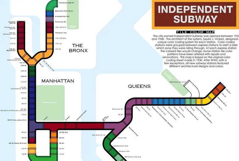
This Map Explains the Historic Tile Color System Used in NYC Subway Stations

We know the crowds that pack into our city’s subway cars each day are more than colorful enough, but the system also has a super-geeky color-coded navigation system that exists even outside of the main map’s primary colored lines. The city-owned Independent Subway was opened between 1932 and 1940. Up until 1967, it was the last of three former competing subway systems, and contributed six major lines to what is now the unified New York Subway: A, B, C, D, E, F, G, Q (partial). Squire J. Vickers, the system’s architect, designed a special color coding system for each station. Color coded stations were then grouped between express stations to make riders aware of the zone they were passing through. At each express station, the color of the tiles would change. Some station tile color patterns have been altered with subsequent renovations. The system map is based on the original color coding sheet from 1930. After WWII, almost all new subway stations featured their own unique architectural designs and colors
Find out what color your stop is
February 16, 2016

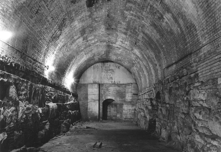
Vaults Under the Brooklyn Bridge Once Held Private Wine Cellars

We know the cavernous passageways and underground chambers of the Brooklyn Bridge hold many secrets–6sqft previously mentioned the Cold War-era bomb shelter, chock-full of supplies and provisions, hidden inside one of the massive stone arches below the bridge’s Manhattan side entrance. But the landmark also harbors a more pleasant secret: In the 1900s, the city rented out vaults beneath the ramps leading up to the bridge entrances for use as wine cellars (h/t NYT). A wine vault on the Manhattan side cost $5,000 a year, while Brooklyn-side storage was a mere $500 annually.
The full story
February 16, 2016

Original World Trade Center Keys Are for Sale on eBay for $489

Today's office buildings are generally accessed via sophisticated swipe cards and code systems, but when the original World Trade Center towers were built, good old fashioned keys were still in use. And, believe it or not, two separate sellers on eBay are offering up said brass keys, Untapped uncovered. The first (pictured above) has raised letters stating, “WORLD TRADE CENTER DO NOT DUPLICATE,” meaning it "was cast in brass and not printed in the locksmith department of the Twin Towers." For $489, it's being sold with a visitor's pass from when the seller's father went to the offices of financial firm Raymond James. The second key is only $250, but has engraved letters instead.
Find out more about these historic items
February 12, 2016

Buyout Legends: Developers Paid 15 CPW Hermit Holdout $17M to Move Into a Free Apartment

What do you do when you're a developer who has a 52,000-square-foot property with one tenant...who won't leave? While we've all heard legends about holdouts in rent-controlled apartments getting big buyouts from deep-pocketed developers, none to date could beat the good fortune of Herbert J. Sukenik. The reclusive septuagenarian lived in his 350-square-foot apartment (which happened to have four exposures and Central Park and two river views) at the Mayflower Hotel for three decades. But he ended up walking away with $17 million, the most money ever paid to a tenant to leave a New York apartment, and walked into an almost-free, 2,200-square-foot, 16th-floor home in the venerable Essex House on Central Park South.
So what happened?
February 8, 2016

The On Leong Tong Building: Chinese Architecture Brought to Life in NYC

If you're planning to head down to Chinatown for the celebration of the Lunar New Year, you'll likely amble past the corner of Mott and Canal Streets, where there is a remarkable building like no other in New York. It's called On Leong Tong, or, in English, the Merchants' Association building. Built in 1950, it combines modernism (though you wouldn't know it to look at it) with familiar Chinese architectural features—the pagoda roof, balconies, colorful columns and so on. Once you've seen it, you won't forget it.
Read the full history of this building
February 4, 2016

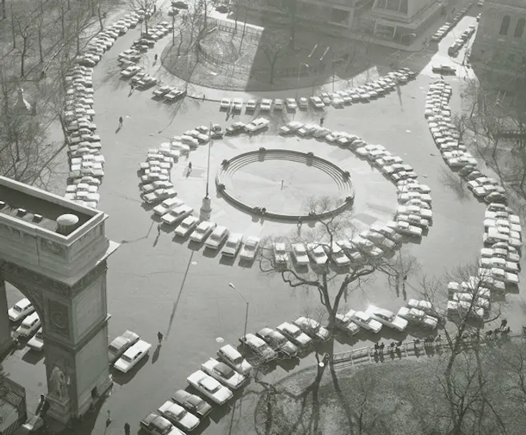
They Paved Washington Square Park and Put Up a Parking Lot

It's true: Washington Square Park was, in part, Washington Square parking lot. In the 1960s, at the peak of the nation's car culture fixation, the Greenwich Village park was put into use as a parking lot, until cars were finally banished altogether in the 1970s, when the large circular plaza around the fountain was added. Some say the parking lot was an effort to keep hippies from gathering in the beloved public space.
Find out more
February 3, 2016

Interactive Website Lets You Listen to New York City in the Roaring ’20s

We love looking at footage from 1920s New York City and watching the bustling street life from a bygone era, but we aren't nearly as familiar with its sounds. The Roaring Twenties, "an interactive exploration of the historical soundscape of New York City," created by historian Emily Thompson, compiles a wealth of historic data to re-create and share the city's sonic history, giving context to the sounds of the city in the 1920s and '30s. In an introduction, there’s a quote from a 1920 New York Times article that speaks of how the city was “defined by its din."
Learn what the site has to offer
February 2, 2016

The Urban Lens: Documenting Gentrification’s Toll on the Mom-and-Pops of Greenwich Village

6sqft's new series The Urban Lens invites photographers to share work exploring a theme or a place within New York City. To kick things off, award-winning authors and photographers James and Karla Murray bring us 15 years of images documenting the changing storefronts of Bleecker Street in Greenwich Village. Are you a photographer who'd like to see your work featured on 6sqft? Get in touch with us at [email protected] Bleecker Street between Sixth and Seventh Avenue South was once a huge Italian enclave with many traditional "mom and pop" stores catering to the large Italian families who resided in the neighborhood. By the late 1930s, it also had a significant bohemian population with many artists, writers, poets and musicians living in the area who set up galleries, coffee houses and music shops. Due to widespread gentrification and escalating real-estate values, the neighborhood has changed drastically and its unique appearance and character is suffering. We are here to take you on visual tour to experience how many of the truly authentic shops remain on this venerable Greenwich Village street, and to show you what has replaced the ones that have vanished. Many of the shops you'll encounter ahead have been featured with full-color photographs and insightful interviews with the store owners in three of our widely acclaimed books on the subject, but we've also rounded up several more ahead.
Walk the Greenwich Village of yesteryear and present
January 27, 2016

Harsenville to Carmansville: The Lost Villages of the Upper West Side

In the 18th century, Bloomingdale Road (today's Broadway) connected the Upper West Side with the rest of the city. Unlike lower Manhattan, this area was still natural, with fertile soil and rolling landscapes, and before long, countryside villages began sprouting along the Hudson River. They were a combination of farms and grand estates and each functioned independently with their own schools and roads. 6sqft has uncovered the history of the five most prominent of these villages–Harsenville, Strycker's Bay, Bloomingdale Village, Manhattanville, and Carmansville. Though markers of their names remain here and there, the original functions and settings of these quaint settlements have been long lost.
Find out the history of these lost villages
January 27, 2016

In 1933, a Ham Sandwich Cost 25 Cents at the Empire State Building Observatory

Today, the only thing you'll be spending money on when you travel to the 102nd floor of the Empire State Building is the $50+ Observation Deck ticket. But back in the '30s, it was a much more glamorous experience, complete with the Empire State Observatory Fountain and Tea Room. The New York Public Library recently digitized 18,000 of its 40,000 restaurant menus, which range from 1851 to 2008, including this one from the Empire State Building in 1933. As you'll see, sandwiches (ham, peanut butter, and tomato and lettuce, to name a few) were a mere 25 cents, the same price as their six types of ice cream sundaes and ten flavored sodas. In terms of actual food, your only choice other than a sandwich would've been a pretty blah-sounding salad, some pastries, or a selection of "candy and cigarettes."
More right this way
January 18, 2016

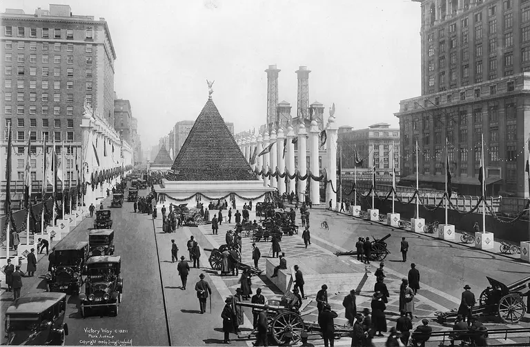
Photo From 1918 Shows a Towering Pyramid of 12,000 German Helmets in Front of Grand Central

Grand Central Terminal has a great deal of hidden history and underground secrets, but this powerful image of German helmets taken in 1918 might not be on everyone's radar. The photo documents a collection of captured WWI helmets from German soldiers stacked in a pyramid shape on Victory Way. The politically potent tower was in view of the employees from New York Central Terminal with the famous train station visible in the background.
More on this alarming photo