New research says Sandy-like storms could occur in NYC every 20 years by the year 2100

Hurricane Sandy damage in Breezy Point, Queens
With the fourth anniversary of Hurricane Sandy approaching, many New Yorkers are still reeling from its devastation; in fact, the city recently allocated another $500 million in taxpayer money for repairs due to storm damage. And though this seems grim, a new study from a group of researchers at Princeton and Rutgers universities and the Woods Hole Oceanographic Institution is even more troubling. Based on a storm-related computer simulation of flooding, “Hurricane Sandy’s Flood Frequency Increasing From Year 1800 to 2100” predicts that in a worse-case scenario, by the year 2100, such powerful storms will occur every 20 years, an increase of 17 times the current state, reports Phys.org.
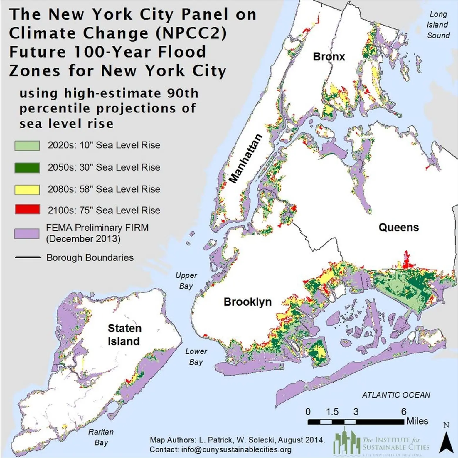
The climate change map released in 2015 by the New York City Panel on Climate Change
Back in February 2015, the New York City Panel on Climate Change released a separate report that said by the end of the century, sea levels in NYC could rise 22 to 50 inches, “meaning the amount of land within FEMA’s proposed flood insurance rate maps will double, covering 99 square miles of the city,” as 6sqft previously noted.
The new study accounts for both sea-level rise and storm activity due to climate change, and its modeling technology not only looked at future storms, but historic ones as well. By looking at past weather patterns, the researchers saw that “Sandy-like surge floods increased threefold during the two centuries from 1800 to 2000.” Based on these patterns, sea-level rise alone will increase the frequency of such storms by 4.4 times, but when the group factored in “changes in storm climatology” this jumps to 17 times.
According to Ning Lin, lead author of the paper and an assistant professor of civil and environmental engineering at Princeton:
What this tells us is that large surge floods are likely to increase in frequency, but that there is a large amount of uncertainty about the extent of the increase…. Engineering-wise we’ve always considered sea level and climate as static, but now we need to account for the change over time. Our work is focused on putting predictions of flooding on a truly quantitative basis by incorporating factors that are predicted to change. If you don’t account for rising sea level and possible change in storm activity, you’re underestimating future flood risk.
[Via Phys.org]
RELATED:


