October 18, 2017

New RPA report is ‘a wake up call’ on rising sea levels and growing flood risk

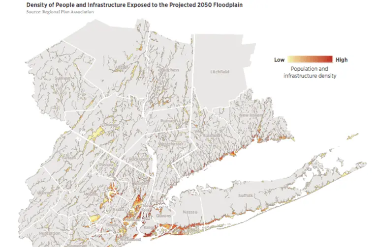
Hurricane season is impossible to ignore, and as the October 29th anniversary date of Superstorm Sandy approaches, the Regional Plan Association (RPA) has released a report titled "Coastal Adaptation: A Framework for Governance and Funding to Address Climate Change" that warns of the imminent threat of rising sea levels and outlines a strategy to protect the many vulnerable stretches of New York, New Jersey and Connecticut. According to the report, 59 percent of the region's energy capacity, four major airports, 21 percent of public housing units, and 12 percent of hospital beds will be in areas at risk of flooding over the next 30 years. RPA research found that even in light of these projections, the region’s climate change planning tends to be reactive and local rather than pro-active and regional–and it's not nearly enough.
Find out more about who's at risk and what can be done
October 3, 2016

Flood regulations may thwart plan to convert Lower Manhattan public spaces to retail

When plans surfaced last March for a rezoning of the Financial District that would allow property owners to bring in retail tenants to the underutilized public plazas and walkways at the base of their buildings, it was met with mixed reviews. While some felt it would increase foot traffic and create a more vibrant street presence, others thoughts it would result in a loss of public space, but a gain for developers. These concerns may be a moot point, however, as Crain's brings news today that the plan could be "upended by federal flood regulations being applied to more areas of the city since Superstorm Sandy."
What's the deal?
February 22, 2016

‘Fatal Flaw Analysis’ Says Brooklyn-Queens Streetcar Could Require Two New Bridges

The proposed Brooklyn-Queens Connector (BQX) streetcar may require the construction of two new bridges, one over Newtown Creek and another over the Gowanus Canal. The New York Times reported that the potential need for the new bridges–the Pulaski Bridge and the bridge across the Gowanus Canal at Hamilton Avenue might not be able to accommodate streetcars–was one of the more substantial details released by Deputy Mayor Alicia Glen and other top officials Friday. In a "fatal-flaw analysis," it was found that that though there would be "major challenges" to creating the system, it was feasible, Ms. Glen said. Like all things New York City, the proposed BQX proposal "would dwarf other recent streetcar systems in the United States." The cost involved in constructing the new bridges is already included in the project's $2.5 billion cost estimate. They would include bicycle and pedestrian paths.
Find out more
February 18, 2016

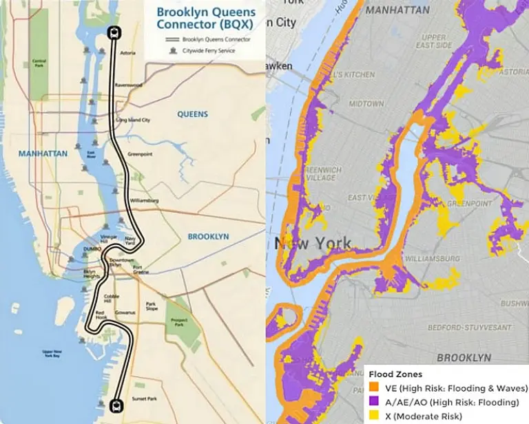
The Brooklyn-Queens Streetcar Would Run Entirely Through Flood Zones

Leading up to Mayor de Blasio's press conference on Tuesday about his proposed Brooklyn-Queens streetcar plan, the internet has been abuzz with criticism and concerns, including whether or not it will accept MetroCard transfers, how it won't really connect to existing subway lines, funding matters, and the issue that the system may favor "tourists and yuppies." But Streetsblog makes another very interesting point–the fact that the proposed route will run almost entirely through city- and FEMA-designated high-risk flood zones, which "raises questions about how the streetcar infrastructure and vehicles would be protected from storm surges, as well as the general wisdom of siting a project that’s supposed to spur development in a flood-prone area."
What does the Mayor have to say about this?

Our Mission

More than just current events, here you'll learn about the places, people, and ideas that are shaping your city.