7 green infrastructure projects shaping NYC’s climate future

As New York City deals with rising sea levels, heavier rainfall, and aging infrastructure, officials are increasingly confronting a future that will be wetter and more climate-vulnerable. Efforts are underway to improve the resilience of the city against extreme weather driven by climate change while expanding greener and more accessible public spaces. These efforts come as President Donald Trump’s administration continues to cancel or freeze funding for programs that address climate change, including $325 million in disaster prevention funds for New York. In honor of Earth Day, we’ve put together a list of seven major green infrastructure projects that are working toward a safe and sustainable future for New Yorkers.
Vital Parks for All

Public green spaces have long been an important resource for New Yorkers, providing areas for recreation and respite. However, with many park facilities now past their intended lifespan and demand for park space increasing, the city’s Parks Department (NYC Parks) has undertaken major upgrades to ensure parks can accommodate current and future generations.
Vital Parks for All is the department’s $3.2 billion commitment to ensuring public spaces across the five boroughs remain the critical infrastructure that they are. Launched in June 2024, the plan seeks to preserve existing park facilities, equitably deliver new park resources to underserved communities, and educate New Yorkers on how they can celebrate and support their parks.
“Our parks and green spaces are critical public resources to providing a livable and equitable city, and our parks system is strongest when it is green, resilient, and supported by a community of engaged and empowered New Yorkers,” a spokesperson for NYC Parks told 6sqft.
“The Vital Parks initiative provides a framework for thinking about and driving change in our public green spaces, ensuring that we’re able to revitalize aging park facilities, deliver new resources where they’re needed most, and empower New Yorkers with the data they need to advocate for their parks.”
NYC Parks has made a $136 million investment to plant more street trees in the city’s most vulnerable communities, $80 million to acquire properties in underserved areas to improve livability and ecological resilience, and $100 million to advance 19 wetland restoration projects in at-risk neighborhoods.
Last month, Mayor Zohran Mamdani announced that 10 NYC parks in underserved neighborhoods will receive $50 million in new investments, continuing city efforts to expand access to green space. The improvements are expected to benefit more than 116,500 New Yorkers.
Alongside the plan, the agency also released an interactive map, the Vital Park Explorer. Through the tool, New Yorkers can explore city data to see their community board’s access to more than 20 park services, ranging from greenways and volunteer groups to dog runs and hiking trails.
Users can also view a Park Condition Score for each site, a composite measure that reflects factors such as cleanliness, safety, and amenities, including playground equipment, landscaping, and restroom facilities.
Prospect Park Bluebelt

Brooklyn is set to receive its first-ever Bluebelt, a nature-based flood prevention system that uses natural landscape features, such as streams, ponds, and wetlands, to better manage extreme rainfall fueled by climate change. In December, the city announced it would invest $68 million in the new infrastructure, which will help protect Prospect Park, nearby neighborhoods, and the Prospect Park Zoo, which closed for eight months in 2023 due to flood damage.
The project was shaped by a year-long study by the DEP into flooding in surrounding Brooklyn neighborhoods and stormwater flow through Prospect Park. Working with NYC Parks and the Prospect Park Alliance, the agencies analyzed the park’s landscape and water systems to identify ways to improve drainage, as 6sqft previously reported.

Bluebelts are an emerging stormwater infrastructure system in the five boroughs. The first was launched on Staten Island, where it spans much of the island’s southern half. As explained by NYC H2O, bluebelts often blend into surrounding parkland and can be mistaken for ordinary green space, rather than the sustainable infrastructure systems they are.
The systems have a wide range of landscape design measures and engineered features. Meandering streams slow the water naturally, allowing sediment that would otherwise be carried downstream to settle before reaching larger bodies of water.
Forebays are specially constructed, rock-lined basins where water is further slowed and sediment is captured. Waterfall-like features, such as step-pool systems, function in a similar way by reducing water velocity as it moves through a series of drops and pools.
DEP is expanding the Bluebelt system wherever feasible across all five boroughs. The agency currently manages 545 acres of bluebelts and natural areas in the Bronx, Queens, and Staten Island. Construction on the Prospect Park project is scheduled to start in 2029 and finish in 2032.
Rain Gardens

Many New Yorkers may walk past these inconspicuous, fenced dirt patches along city streets without taking a moment to notice them, unaware that they are a critical tool in protecting neighborhoods from flooding.
Built by the Department of Environmental Protection (DEP), there are more than 11,000 rain gardens across the five boroughs. These small curbside installations are a cost-effective and resilient way to manage stormwater during extreme weather events.
Typically located next to stormwater catch basins, rain gardens contain highly porous engineered soil and a variety of plants selected for their ability to absorb water and thrive in urban conditions.

Together, these systems help capture and filter thousands of gallons of stormwater before it enters the sewer system, reducing the risk of combined sewer overflows into local waterways during storms. Rain gardens are estimated to collect roughly 8 million gallons of water per year, according to the DEP.
Beyond reducing stormwater overflow, rain gardens also help filter pollutants and improve water quality while adding greenery to city streets, particularly in low-lying, flood-prone areas.
“The DEP continues to expand nature‑based stormwater solutions across NYC. Green infrastructure, like planted curbside rain gardens and Bluebelts, helps drain rainwater off the streets to reduce neighborhood flooding and protect local waterways,” a DEP spokesperson told 6sqft.
South Brooklyn Marine Terminal + Empire Wind
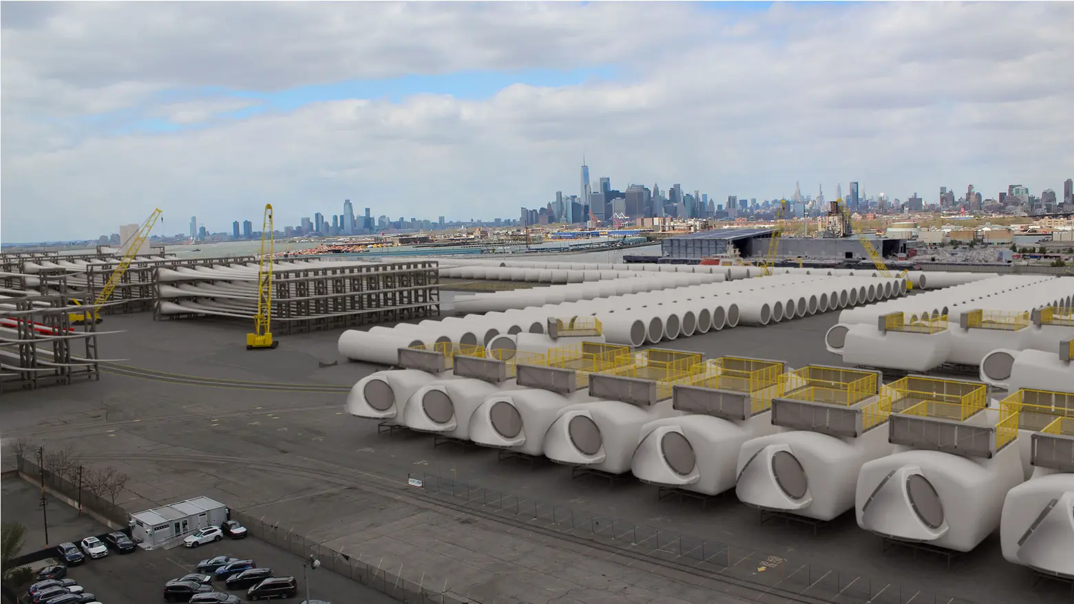
An expansive, 122-acre swathe of Brooklyn’s historic industrial waterfront is poised to become one of the nation’s largest offshore wind ports, with the potential to remove more than 34 million tons of CO2 from the environment. Led by the city’s Economic Development Corporation, the $3.5 billion redevelopment project is transforming the dilapidated marine terminal into thousands of apartments and a 60-acre, all-electric port, as well as an interconnection site for Equinor’s Empire Wind 1 project.
Located roughly 30 miles southeast of Long Island, Empire Wind spans 80,000 acres and is being developed in two phases. Empire Wind 1 will deliver 810 megawatts of renewable energy to Brooklyn, powering about 500,000 NYC homes, and is expected to play a key role in the city’s goal of reaching 9 gigawatts of offshore wind capacity by 2035 and 100 percent clean electricity by 2040.
Empire Wind will be the first offshore wind project to deliver power directly to the five boroughs, bringing it onshore at the Sunset Park Onshore Substation, next to the South Brooklyn Marine Terminal. Fifty-four turbines will be built as part of Phase 1, each with a 15-megawatt capacity, and each turbine rotation will generate enough energy to power a NY home for about 1.5 days.
As part of its agreement with the city, Equinor has agreed to contribute $5 million to an ecosystem fund that will help New Yorkers enter the offshore wind industry and accelerate wind innovation. The company will also open an offshore wind learning center at its Brooklyn office that will be open to the public, as 6sqft previously reported.
The project came under scrutiny from the Trump administration in December, when it froze five major offshore wind projects on the East Coast, citing “national security concerns.” Trump has also referred to offshore wind projects as “losers,” arguing they lose money, damage landscapes, and kill birds, according to the Associated Press.
In response, Equinor sued the federal government to resume construction. In January, District Judge Carl J. Nichols ruled that work on the project could continue while he considers the “merits” of the government’s order to suspend it, saying the government had not adequately addressed key arguments in the developer’s filings.
Lower Manhattan Coastal Resiliency Project

New York City’s coastal location has played a vital role in its development as a global city, with millions arriving in the five boroughs by ship through its harbor, passing landmarks like the Statue of Liberty with the skyline rising behind it. However, in the face of extreme weather events, flooding, and sea level rise driven by climate change, parts of the city will need to adapt to stay afloat.
To confront these risks, the city released the Lower Manhattan Climate Resilience Study in 2019, which examined current and future climate threats across the area. It found that by the 2050s, 37 percent of Lower Manhattan buildings would be at risk of storm surge, rising to nearly 50 percent by 2100. By that time, 20 percent of streets could also face daily flooding due to a projected sea level rise of more than six feet.
Since then, the city has launched the Lower Manhattan Coastal Resiliency (LMCR) project, a wide-ranging initiative aimed at reducing flood risk from coastal storms and sea level rise across Lower Manhattan.
With a projected cost of up to $7 billion, the LMCR includes five key components: Brooklyn Bridge–Montgomery Coastal Resilience, Seaport Coastal Resilience, Battery Park Coastal Resilience, East Side Coastal Resilience, and the North, South, and West Battery Park City Resilience projects.
As part of the Battery Park City project, workers are creating an integrated coastal flood risk management system along the northern border of Battery Park, across Pier A Plaza, through Wagner Park, and to the Museum of Jewish Heritage.
In July, Wagner Park reopened after a two-year overhaul that elevated it 10 feet to conceal a buried floodwall beneath the central lawn, protecting it from storm surge. It also features a 63,000-gallon underground cistern for rainwater reuse and gardens planted with native, salt-resistant species. The park is now designed to withstand a 100-year storm and is expected to offer protection against severe storms through the 2050s based on projected sea level rise.
“The Battery Park City Resiliency Projects are a critical part of the city’s broader initiative to protect Lower Manhattan residents, property and infrastructure against the rising threats of climate change,” a Battery Park City Authority spokesperson told 6sqft.
“With Wagner Park now reopened and construction advancing in North/West Battery Park City, we are proud to deliver a world-class integrated coastal flood protection system that sets a new standard for resilient waterfront design.”

Construction on the Brooklyn Bridge–Montgomery Coastal Resilience Project began in the fall of 2022, while the $1.45 billion East Side Coastal Resilience project opened its first two public areas in 2022 and 2023.
In May, two additional public spaces opened at East River Park, which is being elevated 8 to 10 feet to accommodate a floodwall beneath it. The previous summer, the city reopened Ballfields 1 and 2 with an upgraded drainage system and other improvements designed to withstand climate impacts.
Tibbetts Brook Daylighting

A stream in the Bronx’s Van Cortlandt Park, buried for more than a century, is being restored as part of an effort to improve water flow and reduce flooding and sewage overflow into the Harlem River. The process, known as “daylighting,” removes concrete and other coverings above waterways in an effort to restore natural flow and surrounding ecosystems, according to Smithsonian Magazine.
Daylighting has grown in popularity as cities across the United States face increased flooding from more frequent and intense rainstorms. The process also brings additional benefits, allowing cities to introduce new plantings and create new green spaces. Environmentalists have advocated for the daylighting of Tibbetts Brook for decades.
Starting in Yonkers and running through Kingsbridge before reaching Spuyten Duyvil Creek, Tibbetts Brook once flowed entirely above ground before it was buried in 1912 to make space for development, according to Starr Whitehouse.
Since then, clean water from the buried stream has entered the Harlem River, adding about 2.2 billion gallons of freshwater to antiquated pipes that carry combined sewage and stormwater to treatment plants. In 2021, rainfall from Hurricane Ida overwhelmed the system, sending floodwaters up to six feet deep in Van Cortlandt Park and turning parts of the nearby Major Deegan Expressway into a river.


As part of the $133 million plan, roughly 1.8 miles of the stream will be brought back above ground from Hester and Piero’s Mill Pond to the river. The project is expected to prevent the brook’s clean water from entering the sewer system and reduce sewage overflow into the Harlem River by roughly 220 million gallons per year. It is also expected to be one of the city’s most cost-effective green infrastructure investments, leveraging natural systems to create a “greener, more connected public realm.”
Led by Starr Whitehouse in collaboration with Hazen and Sawyer, the project also includes ecological upgrades along the daylighted brook and extends the Putnam Greenway by 1.2 miles from Van Cortlandt Park to West 230th Street, complementing the ongoing expansion of the Harlem River Greenway. The improvements are expected to enhance park access and help reduce flooding by expanding green space.
While construction to daylight the brook was initially set to begin in 2025, the start was delayed as the city worked to complete key land deals and easements. In the meantime, the city has been removing invasive species from the area since August 2024, according to Secret NYC. The initiative is now expected to break ground this year, with the fully daylighted stream slated to open around 2030.
Arverne East
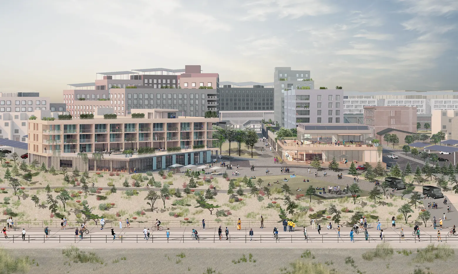
Currently taking shape on a formerly vacant 116-acre oceanfront site in the Arverne and Edgemere neighborhoods of Far Rockaway, Queens, Arverne East is slated to become NYC’s first net-zero community. With a price tag of nearly $1 billion, the project is expected to generate more energy than it consumes through passive house construction and an innovative geothermal system, making it a model for sustainable development across the five boroughs.
Spanning from Beach 32nd Street to Beach 56th Place, the site was acquired by the city and cleared for development in the 1970s, but remained largely untouched for about 50 years. The project will ultimately include 1,650 housing units, with a mix of affordable, market-rate, and homeownership opportunities.
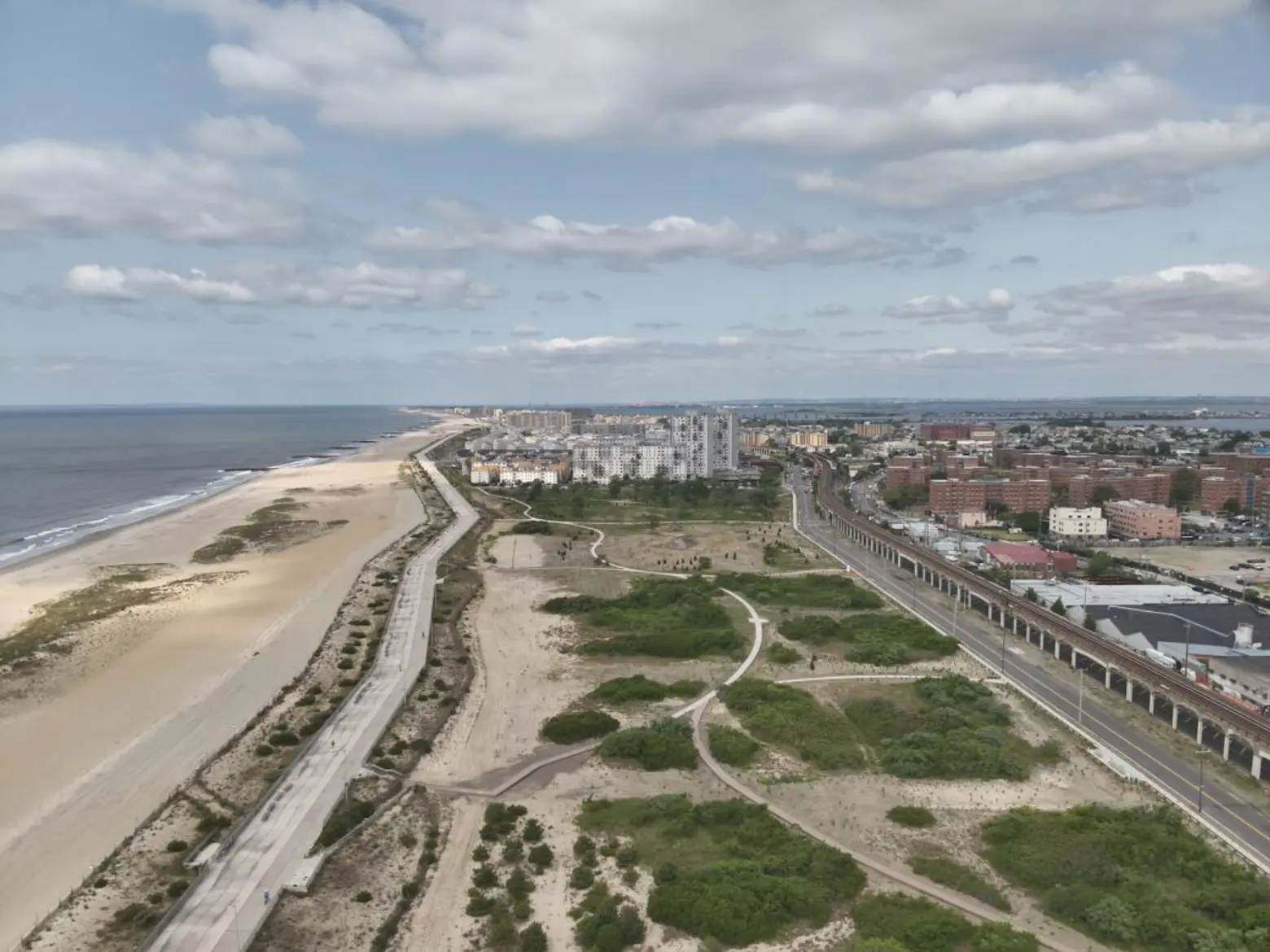
It also includes a 35-acre nature preserve, designed by Starr Whitehouse, which opened to the public in April 2024 as part of the project’s first phase. Stretching between Beach 44th Street and Beach 56th Place, the preserve features a winding pathway that guides visitors through five distinct ecologies: maritime forest, shrubland, grassland, swale, and dunes.
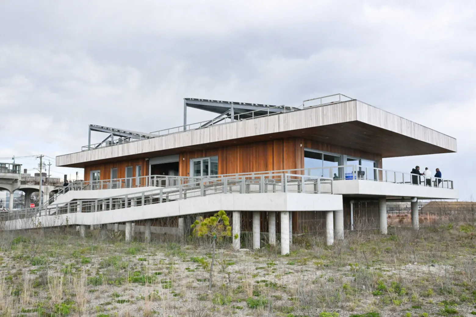
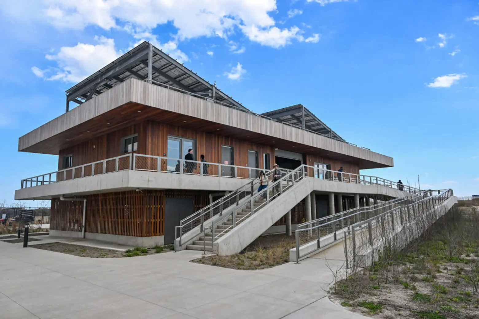
The preserve also includes a 6,000-square-foot welcome center designed by WXY, which incorporates the same sustainability measures as the broader development and is fully fossil fuel-free, with a closed-loop geothermal system for heating and cooling and a rooftop solar array to power the building
Beyond the center, Arverne East will feature a range of resilient design elements to protect against flooding, which has historically impacted the Rockaways during extreme weather events. The development includes permeable surfaces, planted areas, and bioswales to manage stormwater, while buildings are elevated three to eight feet above existing grade, exceeding the city’s flood elevation standard by up to four feet.
Arverne East is being developed by L+M Development Partners, the Bluestone Organization, and Triangle Equities, in partnership with the city’s Department of Housing Preservation and Development, NYC Parks, and the Department of Transportation.
Arverne East Building D, the first residential phase of the project, is slated to break ground at the end of April. The phase will deliver 320 homes, including 220 affordable rentals and 90 affordable homeownership units.
RELATED:


