Historic Maps

April 29, 2019

New ‘Then and Now’ map shows over 2,200 historic buildings in Greenwich Village

To celebrate the 50th anniversary of the landmark designation of the Greenwich Village Historic District on April 29, 1969, Village Preservation has released an online map and tour of the district. The online tour shows each and every one of the over 2,200 buildings in the district as they looked in 1969 and today.
Find buildings on the interactive historic district map and more
September 15, 2017

Explore 1980s NYC street by street with this interactive map

From Broadway to Bowery, 1980s New York City was a very different place compared to today's manicured metropolis. Courtesy of Maps Mania, the 80s.NYC street map picks up where the Finance Department of New York City left off. In the mid ‘80s the bureau photographed every single building in the five boroughs in order to accurately assess building taxes and estimate property taxes. Brandon Liu and Jeremy Lechtzin have finessed this trove of photographic information into a nifty map that allows users to travel the city's streets in the bad old 1980s with a map-based street view for an easy-to-browse glimpse of the streetscape 30 years ago. You can browse by location by clicking anywhere on the map for vintage street views on that spot, or type in an address. For more context there are curated “stories” that provide historical background where it’s available (and interesting).
Check out the map
July 17, 2017

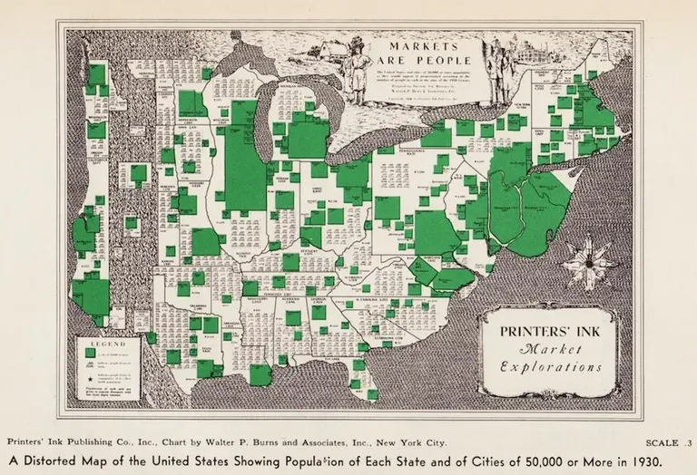
Vintage maps reflect the population distribution of Americans in 1930

Using the 1930 census for their data, two distorted maps show where residents in the United States lived during this period of time. Both vintage cartogram maps exhibit how bunched Americans were in the north and the east coast, clustered in urban areas, despite the westward expansion of the previous century. As the Making Maps blog first featured and as Slate discovered, the size of New York and New Jersey grows in proportion to its expanding populations, moving further east into the ocean.
Find out more
April 27, 2017

NYPL’s ‘digital time travel’ maps let you compare today’s New York City with the past

6sqft previously reported on the "time machine" map function that allowed users to navigate overlaid maps from 1600 to the present to see what used to occupy our favorite present-day places. Now, the New York Public Library has released the Space/Time Directory, a “digital time-travel service” that puts the library’s map collection–including more than 8,000 maps and 40,000 geo-referenced photos–to work along with geospatial tools to allow users to see the city’s development happen over more than a century, all in one convenient place. Hyperallergic reports that the project, supported by a grant from the Knight Foundation, plots 5,000 digitized street maps across the five boroughs, organized by decade from 1850 to 1950.
Find out more
February 24, 2016

How Far From NYC You Could Travel in One Day Between 1800 and 1934

Back in 1800, a New York stagecoach couldn't get outside the northeast, and a trip to Charleston, South Carolina took ten whole days of sailing—these are just two examples of just how arduous traveling in the 19th and early 20th centuries was. To visualize this difficulty, as well as to show the major advances made over a relatively short time, Quartz created this simple map that shows how far from NYC one could travel in a day between 1800 and 1934.
More on the map
August 21, 2015

Amazing Detailed Map from the 1950s Shows 300+ ‘Wonders of New York’

Click to expand >> One of a growing collection of transit maps, this cool detailed New York City map, designed by graphic designer/sailing enthusiast/IBM employee Nils Hansell sometime around 1953-1955, offers a mind boggling tableau of (mostly) Manhattan's points of interest, numbered, with a corresponding key. There's also a color-coded schematic to the subway system, which was at the time divided up by its operators, BMT, IND and IRT; the map also shows a remaining few of the city's elevated railway systems, the last of which was ended in 1955.
Check it out here